


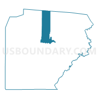
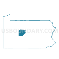
LAWRENCE TWP PCT PLYMPTON, Clearfield County, Pennsylvania
About
Outline

Summary
| Unique Area Identifier | 658609 |
| Name | LAWRENCE TWP PCT PLYMPTON |
| County | Clearfield County |
| State | Pennsylvania |
| Area (square miles) | 55.77 |
| Land Area (square miles) | 55.58 |
| Water Area (square miles) | 0.19 |
| % of Land Area | 99.66 |
| % of Water Area | 0.34 |
| Latitude of the Internal Point | 41.11059800 |
| Longtitude of the Internal Point | -78.44035300 |
Maps

Graphs
Select a template below for downloading or customizing gragh for LAWRENCE TWP PCT PLYMPTON, Clearfield County, Pennsylvania


Neighbors
Neighoring Voting District (by Name) Neighboring Voting District on the Map
- BENEZETT TWP Voting District, Elk County, PA
- BRADFORD TWP PCT 02, Clearfield County, PA
- CLEARFIELD WD 03, Clearfield County, PA
- CLEARFIELD WD 04, Clearfield County, PA
- GOSHEN TWP Voting District, Clearfield County, PA
- HUSTON TWP Voting District, Clearfield County, PA
- JAY TWP VTD CALEDONIA, Elk County, PA
- JAY TWP VTD WEEDVILLE, Elk County, PA
- LAWRENCE TWP PCT GOLDEN ROD-HILLSDALE, Clearfield County, PA
- LAWRENCE TWP PCT HYDE CITY, Clearfield County, PA
- PIKE TWP Voting District, Clearfield County, PA
- PINE TWP Voting District, Clearfield County, PA
Top 10 Neighboring County Subdivision (by Population) Neighboring County Subdivision on the Map
- Lawrence township, Clearfield County, PA (7,681)
- Clearfield borough, Clearfield County, PA (6,215)
- Bradford township, Clearfield County, PA (3,034)
- Pike township, Clearfield County, PA (2,311)
- Jay township, Elk County, PA (2,072)
- Huston township, Clearfield County, PA (1,433)
- Goshen township, Clearfield County, PA (435)
- Benezette township, Elk County, PA (207)
- Pine township, Clearfield County, PA (60)
Top 10 Neighboring Place (by Population) Neighboring Place on the Map
Top 10 Neighboring Unified School District (by Population) Neighboring Unified School District on the Map
- DuBois Area School District, PA (30,976)
- Clearfield Area School District, PA (19,134)
- St. Marys Area School District, PA (18,979)
- Curwensville Area School District, PA (7,365)
Top 10 Neighboring State Legislative District Lower Chamber (by Population) Neighboring State Legislative District Lower Chamber on the Map
Top 10 Neighboring State Legislative District Upper Chamber (by Population) Neighboring State Legislative District Upper Chamber on the Map
- State Senate District 41, PA (236,058)
- State Senate District 25, PA (233,497)
- State Senate District 35, PA (232,251)
Top 10 Neighboring 111th Congressional District (by Population) Neighboring 111th Congressional District on the Map
Top 10 Neighboring Census Tract (by Population) Neighboring Census Tract on the Map
- Census Tract 3310, Clearfield County, PA (5,098)
- Census Tract 3305, Clearfield County, PA (4,568)
- Census Tract 3313, Clearfield County, PA (4,427)
- Census Tract 3314.02, Clearfield County, PA (3,570)
- Census Tract 3311, Clearfield County, PA (3,319)
- Census Tract 3306, Clearfield County, PA (3,254)
- Census Tract 3312, Clearfield County, PA (2,896)
- Census Tract 3307, Clearfield County, PA (2,306)
- Census Tract 9509, Elk County, PA (2,279)